 |
||||||||||||
 |
||||||||||||
 |
||||||||||||
|
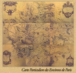
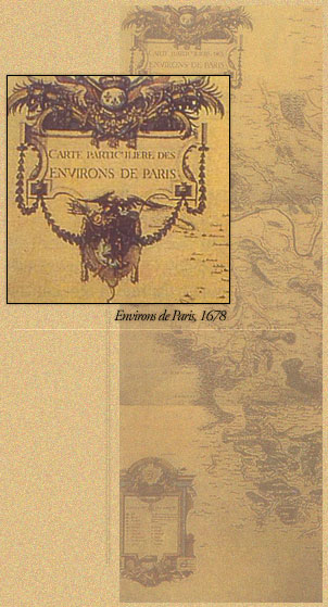
The Da Vinci Chalice Group The Lost Chalice of Da Vinci MIAMI/EWORLDWIRE/Sep. 28, 2007 – In another project, the Da Vinci Chalice Group proudly announced that one of the most rare, and priceless maps in the world will go on its first public exhibition in over 300 years. The Group stated that this has been a twenty-year project. The map, "Le Carte Particulier Des Environs de Paris," dated 1678, is nine-sheets of 45 X 41 cm. each. A bird's eye view of Paris, it is considered to be the first correct metric style map, and the only known hand-colored copy. As discussed in the book, The Story of Maps, by Lloyd A. Brown, this is not just a map. It represents a scientific and historic event. From 1671, the mapping enterprise took over seven years to create and was a major financial investment for the Crown, according to M. Colbert, the 17th. c. finance minister of the Royal treasury of France. The map was made for Louis XIV King of France - "The Sun King," as it was his desire to document and demonstrate his wealth, achievements and a superior status within the community of competing nations of Europe: the structures, the footprint and magnificence of design, and simply his city, Paris, unequalled in the world at the time. The work on the map of Paris was directed by Jean-Dominique Cassini, director of the French Royal observatory, hand-colored by Charles Le Brun - the first painter to the King and designer of the Chateau de Versailles, and considered by many to be one of the great artists in French history. The creation of this map involved a huge cast of historically important figures of the period. Scientists and intellectuals from all over Europe worked on the project. The metric system, invented by the French, allowed cartographers of all nations to standardize, accurately measure, and map the earth and the universe. Most historians agree that Gabriel Monton, the vicar of St. Paul's Church in Lyons, France, "was the founding father of the metric system." He proposed a decimal system of measurement in 1670. Over the preceding decades, his work was revised and improved, by other European scholars. The achievements by these great men, Monton, Cassini, Huygens, Picard, Galileo and others, eventually moved later generations to explore and map the world, space and eventually visit the stars, with precision. A black and white copy of this map is registered at the Bibliotheque National Paris, France. A second black and white copy is recorded in the Queen of England's Royal Collection in London, England. ______ For further inquiries and feedback contact, davincichalice@gmail.com or thedavincichalice@gmail.com and the home Web site at http://www.TheDavinviChalice.com. HTML: http://www.eworldwire.com/pressreleases/17696 CONTACT: Paul Benson [davincichalicegroup] 21218 Saint Andrews Blvd |
||||||||||||
|
The Davinci Chalis Group |
||||||||||||
 |
||||||||||||